On a normal weekday, you might pass one or two other hikers on this trail, but on a holiday, I saw a dozen rock climbers practicing rappelling techniques down the salmon pink cliffs in Carlisle Canyon. Balanced Rock, with the shape and countenance of a contented Buddha, watched over the human spiders. The cliffs in this region appear to be sandstone, but the unique outcroppings are the result of intense earthquake and volcanic action.
An invigorating chill in the air kept me marching through a tunnel of sumac to Split Rock, a volcanic breccia split into three pieces. In February, millions of Ladybugs congregate here to mate. They cling to the low shrubs in churning cinnamon clusters, and you can hear them scuttling across dry leaf litter. I took a rest at the picnic table beside the stream silently stealing over river boulders beneath a canopy of sycamore, oak and laurel trees.
It was easy to imagine the native Chumash people living happily here in this lush woodland. Traces of their village, in nearby Leo Carrillo Beach, date them back about 7,000 years. They came into these foothills to gather acorns, black walnuts and to hunt game. They pounded the acorns from the Oak trees to a fine powder in rock mortars. From the acorn base they created a bland paste, much like poi, that was the stable of their diet.
My favorite part of this hike is the sunlit stretch through the sheltered meadow beneath a stack of pudgy terra cotta boulders in upper Arroyo Sequit. Hoodoo formations here look like Martian homesteads dropped from the sky. Solution pockets, peppering the face of the great rocks, make nice homes for raptors that include the golden eagle, turkey vulture and Cooper’s hawks. I made a mental note to return here in April when one of the flashiest wildflower shows in North America will be in full swing. The hills are blanketed in powder blue and lavender ceanothus known as California Lilac and the meadows spiked with stands of purple lupine.
I often see bobcat enjoying a sunbath on my walks in the mountains. Deer and coyote are common. I felt honored the day a mountain lion flashed across my path, as there are only eight of the big cats left in the entire park. Efforts are in place to create wildlife corridors connecting the Simi Hills, Santa Susana Mountains and the Los Padres and Angeles Forests. The wild fragmented by ever increasing development is in danger of being lost to us forever. Corridors beneath freeways would insure a natural habitat large enough to sustain creatures like the mountain lion and gray fox. After a hard won battle against developers the Santa Monica Conservancy acquired a strategic parcel of land in Liberty Canyon for this purpose.
The 67-mile Backbone hiking trail that runs across the ridge of the Santa Monica Mountains from Will Rogers State Historic Park in Pacific Palisades to Oxnard also serves as a corridor for wildlife. Without fences it allows the east/west movement of large animals, as well as serving the hiking public. The 7,000 acres around the Circle X Ranch, donated by the Boy Scouts, became a part of the Conservancy in l987. The Backbone Trail connects 60,000 acres of open space. Presently, there is a three-mile gap in the trail between the Circle X and Encinal Canyon. The Conservancy is working to acquire the missing link that will complete the seventy-mile stretch insuring a means of safe passage for wildlife into future generations.
Located along the Pacific flyway, over 384 species of birds have been sighted in the park. Butter-butt warblers flit in and out of the pungent sagebrush, buckthorn and manzanita trees. I could hear the industrious scratching of towee and thrashers searching for grubs in the leaf litter, as I strolled through a stand of toyon trees heavy with red berries this time of year. Fat red-tailed hawks hovered over the meadow of gold, gray and purple grasses waiting for the errant rodent. A startled covey of mountain quail beat their wings hard to get out of my path, while the mourning dove cooed from a safe distance.
After an easy march across the top of the ridge of Bony Mountain where the Chaparral community, the most characteristic of southern California landscapes with the thick, leathery leaves of drought tolerant species thrive, a sharp incline takes you to the Backbone Trail and Sandstone Peak. You will see conspicuous stands of red shank, a tall feathery shrub with reddish-brown shredded bark along the way, rarely seen elsewhere in the park.
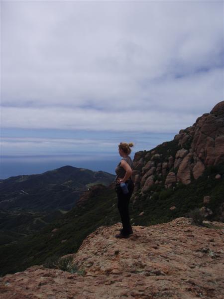
It’s worth a bit of extra effort to take the steep steps up to the monument at the top of 3,111-foot Sandstone Peak. A frothy bank of white clouds drifted over the wind-rippled ocean far below. Straight ahead, San Nicholas, the tiniest member of the Channel Islands, was clearly visible. Santa Catalina slept like a lazy crocodile on the horizon. To the north, the snow-dusted Los Padres Mountains overlooked the flower fields of Oxnard and the Ventura Marina. Twelve miles away, Lake Sherwood, a lonesome sapphire in a setting of multi-million dollar mansions, glittered in the sun.
I sucked in the crisp air, and faced the wind whipping the emerald green foothills. A plaque at the top of the mountain says, “Whoever reaches Inspiration Point has met another challenge.” Satisfied that I had met mine to leave the world behind for a few hours, my mind turned to thoughts of seafood; steamed clams, oysters and crab.
I followed the Backbone Trail back to my car, about a thirty-minute straight shot down the face of the mountain, and headed for Neptune’s Net. Celebrities from Malibu, bikers, surfers, hikers and seafood nuts haunt this funky beach cafe. In the fifties when it opened, the cooks had to double as bouncers. One year, the restaurant was robbed over a dozen times. The Harley set wasn’t made up of doctors, lawyers and the likes of Jay Leno back then. The crowd was a burly bunch that parked their bikes out front where they could keep a close eye on them.
Since Michelle and Chong Lee purchased the hangout in 1991, the “Net” has received a facelift. An outdoor picnic area and a huge parking lot where bikers show-off, are some of the improvements. The Net’s bright yellow and blue paint job is left over from the last surf movie filmed there. The unpretentious, no-hype atmosphere of the “Net” snares an eclectic, star-studded crowd. Michelle Pfieffer, Arnold Schwarzenegger and Cher are among the hundreds who have rolled into the parking lot on their motorcycles to compare chrome, and talk road trips. Often used as a location site for the studios, Tom Cruise’s film, “Losin’ It”, was shot here.
Strictly casual, there are picnic tables lined up under an outdoor canopy overlooking the ocean. Packs of riders rumble in from romps on their gleaming machines to shed leather jackets, rest in the sun and have a cool one. Baskets of fried oysters, clam strips, calamari and great clam chowder keep the crowds lined up at this unassuming surfer shack all summer. Surfers still in wetsuits come to wrap their lips around steamed lobster fresh from the holding tanks. Thankfully, Neptune’s Net is open on most major holidays. A cool drink from the Net’s mini-grocery store and a succulent Dungeness crab later, I headed for home feeling satisfied and “free at last“, after a great outdoor day in L.A.
.
The fastest way to cut loose from the crowds in L.A. is to drive up Pacific Coast Highway, about a half-hour drive north of Santa Monica, just above the Ventura County Line, make a hard right turn and head for the heavens. Yerba Buena Road, just past Neptune’s Net, snakes 6.5 miles up the rim of Sycamore Canyon, through pasturelands sheltered from the blustery coastal winds, to the Backbone Trail parking lot. Stop to register your intentions to hike in the park with the Rangers at the Circle X, a mile before the parking lot, and pick up a map of the trails.
The six-mile Sandstone Peak loop, one of the earliest acquisitions in the Santa Monica Mountains Recreation Area, offers a mixed sampler of early California plant communities and takes you to the highest point in the park. The carrot on the end of the stick for your hiking efforts is an eye-popping view of the coastline from Santa Barbara to the Pacific Palisades peninsula.
Unless you are training for the triathlon, and enjoy a steady uphill climb, I suggest you bear to the right on the trail marked Mishe Mokwa connecter, and start your adventure from the south side of the mountain. The first half-mile of the trail was damp from a recent downpour when I entered it on Martin Luther King Day.